After hearing a wonderful talk given by Professor Carenza Lewis last weekend in Norwich, I have started to look at different ways we can engage our pupils with the Historic Environment using some brilliant technology accessed via the internet.
http://lidarfinder.com/ is a brilliant website that can help us to cut through forest, foliage and other obstructions to see the shape of the land below. The example shown below is Wymondham in Norfolk. Wymondham is not well known for its castle. The Norfolk Heritage Explorer states “This isolated part of the Stanfield estate contains the remains of a large ring motte thought to have been built by the D’Albinis between 1088 and 1139. The feature is over 160m by 120m, with a large bank and water filled ditch, though the internal area also appears to be filled with irregular water-filled pits or ponds. It is thought that a gold ring of Katherine Bigot, wife of Roger Fitz-Ortet who held Stanfield Manor AD 1306, was also recovered from this area.”
The following image taken from Google Maps, shows how overgrown the site it; it simply isn’t possible to get any idea that this was a fortified site in the past. 
When you view the site through the website www.lidarfinder.com, change the setting to environment agency LIDAR DTM 1m, a completely different picture is revealed… The trees and undergrowth have been stripped away to reveal a clear and intriguing circular earthwork dating to the turbulent period after the Norman conquest. Further questions could be asked by pupils about the potentially associated markings to the east of the main road. 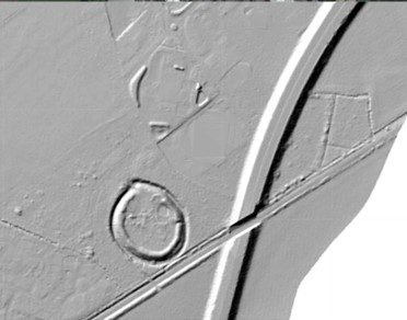
So how could this be used? Its early days yet, but my initial thoughts are that I will begin to use this with our school History Club after half term to see what we can find and how pupils can begin to interpret these hidden landscapes. Any suggested sites would be great!